Nestled amidst the towering peaks of the Himalayas, Kargil, with its rugged terrain and breathtaking landscapes, stands as a testament to nature’s grandeur and human resilience. This region, known for its historical significance and high-altitude adventures, invites travelers to explore its unique blend of culture, history, and awe-inspiring vistas.
1. Historical Tapestry:
Kargil holds a prominent place in the historical tapestry of India. The town gained international attention during the Kargil War in 1999, a conflict that unfolded along the Line of Control.
2. Spectacular Landscapes:
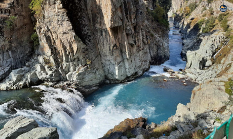
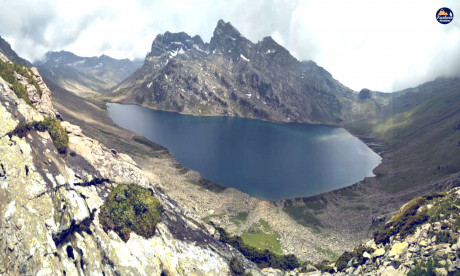
Surrounded by snow-capped peaks, Kargil boasts spectacular landscapes that captivate the hearts of adventurers. The barren beauty of its high-altitude deserts, pristine lakes, and meandering rivers make Kargil a paradise for nature enthusiasts and photographers.
3. Adventure Awaits:
For thrill-seekers, Kargil offers a playground of adventure activities. From trekking in the Zanskar Valley to mountaineering in the Nun Kun massif, the region provides opportunities for high-altitude adventures that test the mettle of adventurers.
4. Suru Valley’s Serenity:
The nearby Suru Valley adds another layer of serenity to Kargil. Surrounded by lush greenery and picturesque landscapes, the valley offers a peaceful retreat for those seeking solace amidst nature’s beauty.
5. Monastic Marvels:
Kargil is dotted with monasteries that showcase the region’s rich cultural heritage. The Mulbekh Monastery, with its rock-carved Buddha statue, and the Phuktal Monastery, perched dramatically on a cliff, are among the cultural gems waiting to be explored.
6. Warm Hospitality:
Despite its challenging terrain, Kargil is known for the warmth and hospitality of its residents. Visitors often find a welcoming spirit in the local communities, making their stay a memorable cultural experience.
7. Gateway to Ladakh:
Serving as a gateway to Ladakh, Kargil is strategically located on the Srinagar-Leh highway. Travelers embarking on the road journey from Srinagar to Leh pass through Kargil, enjoying panoramic views and acclimatizing to the high-altitude conditions.
8. Dras – The Second Coldest Inhabited Place:
Just a short drive from Kargil lies Dras, often referred to as the “Gateway to Ladakh” and known as the second coldest inhabited place on Earth. The Dras War Memorial pays tribute to the soldiers who valiantly defended the region during the Kargil War.
In the heart of Kargil’s stark landscapes lies a destination that beckons those seeking adventure, history, and the untamed beauty of the Himalayas. Kargil stands as a testament to the spirit of resilience and the allure of high-altitude escapades, inviting travelers to discover the land where every peak tells a story.